About cookies on this site Our websites require some cookies to function properly (required). In addition, other cookies may be used with your consent to analyze site usage, improve the user experience and for advertising. For more information, please review your options. By visiting our website, you agree to our processing of information as described in IBM’sprivacy statement. To provide a smooth navigation, your cookie preferences will be shared across the IBM web domains listed here.
Blog Post
Leveraging Earth intelligence for forest analysis
Explore how Environmental Intelligence APIs enable developers to analyze forests with advanced geospatial tools and data sources
The Environmental Intelligence APIs include above-ground biomass estimation model output, historical weather data, environmental insights, complex data querying, and greenhouse gas emission calculations. These APIs are designed for developers and data scientists working with Earth intelligence data.
Register today to get started with a Free Environmental Intelligence APIs preview.
Why forest analysis?
Apart from the mythical stories about forests, how humans harvest and nurture forests has always had an impact on the environment. An example of human impact on a region due to deforestation was given by the Greek philosopher Plato, who described soil erosion near Athens. It is understood today that forests play an important role in the ecosystem for carbon sequestration, protecting soil from erosion, and supporting biodiversity.
To understand the actual state of forests globally, several methods are being applied, all of which have different challenges. Manual analysis is undertaken for select use cases, such as inspection for insects or fungi. Overflight orthophotos are taken for inventorying by public institutions using planes or drones, and satellite imagery is available globally at different resolutions. The volume of data for orthophotos as well as satellite data requires significant computing power.
There are different types of forests and forest uses; for instance, primary forests and timber forests have different compositions, and the perspective with which technology can be applied is different. Primary forests are more efficient at sequestering carbon, and attention is being directed toward nurturing these globally. The composition of a forest is important in a changing climate since mixed forests reduce the risk of damage. It is also of interest to differentiate between wildfires and slash-and-burn events, as well as to find the origins of a fire.
The requirements for analysis are becoming broader as regulations, such as the European Union Regulation on Deforestation-Free Products (EUDR), are being introduced.
What are the key industry use cases?
- Agriculture and supply chain: Monitor produce origin to ensure it is deforestation-free.
- Forestry and public sector: Analysis of monocultures and mixed cultures impacted by climate changes and adaptation.
- Public sector: Municipal tree health analysis.
Public sector: Carbon sequestration analysis with Above Ground Biomass estimation.
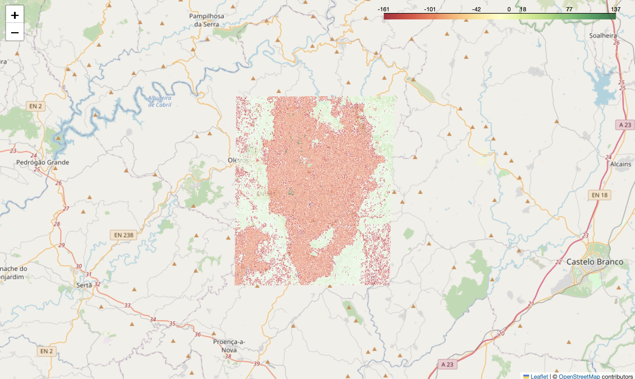
Figure: Analysis of historical AGB differences in an area affected by wildfire
What are the recommended data sources?
As part of the Environmental Intelligence APIs, you have access to the geospatial APIs, which do not need to be downloaded and are queried using Jupyter Notebooks or Python. You can access hundreds of geographic information system layers from diverse environmental and ecological sources, including air quality, wildfires, ocean conditions, and economic trends.
These data sources provide different temporal resolutions, which will help in monitoring regularly and detecting changes.
Check out the IBM Environmental Intelligence APIs data sources catalog, a resource offering diverse geospatial and environmental datasets to enhance your analytical and sustainability projects.
The recommended data sources specifically for analyzing forest data include:
ESA Sentinel 2 for NDVI calculations
The Normalized Difference Vegetation Index (NDVI) is used to quantify greenness. The results from these calculations can be used for tree health analysis, which may include analysis of specific monocultures affected by climate impact. An analysis of the composition of fir and leaf trees within an area is possible by comparison of seasonal analysis outside the tropics and subtropics.
For a practical example of using NDVI for agriculture monitoring, check out this NDVI Analysis Notebook.
If you're looking to explore satellite data for investigating plant health, you can follow along with this free course on Cognitive Class.
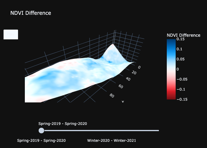
Figure: Calculated NDVI differences for a forest analysis in East France 2019-2020
Historical difference in Above Ground Biomass
As given in the example, the calculation of historical difference in AGB can help determine the impact of wildfires, as well as legal or illegal harvesting in regions of interest.
For a hands-on example of how to analyze historical differences in AGB and assess the impact of deforestation events, check out this Historical Difference in AGB Notebook.
If you're interested in exploring how to analyze forest cover loss due to wildfires using geospatial data, consider taking this free course on Cognitive Class.
ERA5 for soil moisture and temperature
This reanalysis dataset includes historical temperature data, as well as 4 layers of soil water at different heights. These datasets can be used to contextualize the previous calculations by calculating historical changes in soil moisture, which is important for plant growth, and changing temperatures, which have an impact on different tree species.
SoilGrids
Digital soil mapping, including soil profile data and environmental layers, which can be used for further context when analyzing datasets. Correlate this with your calculation or map as a layer in your notebook.
Related information and next steps
For further insights into developing environmental intelligence solutions, check out the following resources:
IBM Environmental Intelligence: A developer's toolkit for sustainable innovation: Stay updated with the latest developments and use cases of IBM's Environmental Intelligence APIs.
Learning Path: Environmental Intelligence: Explore a comprehensive learning path to master environmental intelligence and its practical applications.
Top 5 challenges faced by environmental application developers: Explores the top 5 challenges faced by environmental application developers and insights into overcoming them using innovative solutions.
Geospatial and Environmental APIs – Hands-on projects: Learn by doing with hands-on projects designed to build your skills in geospatial and environmental API integration.
These resources provide valuable guidance for developers looking to build climate-resilient solutions and leverage the power of environmental data in their applications.
If you want to solve complex environmental problems, IBM Environmental Intelligence provides the data and tools needed to build innovative, sustainable applications.
Visit the website today for a free preview !